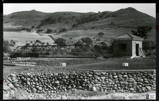
Lithia Springs Bridge
From Siskiyou Boulevard near the University, take Highway 66 (Ashland Street) out of Ashland toward Klamath Falls. In about 2 miles, turn left onto Dead Indian Memorial Road. In about 0.4 miles, turn left into the Ashland Municipal Airport, Sumner Parker Field. From the administration building, the bridge can be seen with binoculars across the runway. Don’t walk across the runway without permission from staff in the administration building.
According to the Ashland Tidings of May 3, 1915, the City of Ashland signed a contract with the engineering firm of Smith,Emery & Co. of San Francisco. The contract was signed on March 4, 1915, and committed Smith, Emery to develop the Lithia Springs site (now the Ashland Gun Club) and pipe lithia water into the City of Ashland. The site development included a pedestrian bridge across Emigrant Creek, for use of the site as a park. The Ashland Tidings of October 14, 1915 reported that the steel bridge was completed.
Over time, the site went through a series of uses that did not utilize the pedestrian bridge. According to a report to the City of Ashland by George Kramer (Memo to Ashland City officials re: Lithia Springs Property [Ashland Gun Club], July 7, 2005) in 1989 or 1990 the city had the bridge moved to the Ashland Municipal Airport, with the intention of placing it across Neil Creek to allow airport visitors a shorter walk into Ashland. According to Bill Skillman of the Airport Commission, the FAA refused to allow the bridge to be placed out of safety concerns over pedestrians walking across the runway. As a result, the bridge lies covered in brush near Neil Creek, on the south-west side of the airport. It can be seen on Google Earth.
