Skip to main content
Toggle navigation
H
istorical
M
arkers &
S
ites In
J
ackson
C
ounty,
O
regon
HOME
About Us
Ask Us a Question
Leave a Message
All Markers
Map
The 1800s
Bridges & Ferries, 1800s
Mining
Native American
Railroads
Roads
Applegate Trail
Siskiyou Mountain Wagon Road
Town Sites - Cemeteries
Agriculture
Heritage Trees
Government
Airports
CCC Camps
Covered Bridges
Law Enforcement
Military
Municipal Markers
Private Memorials
Help
In the countryside
Location
Title
Images
West
Logtown Cemetery
Northeast
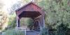
Antelope Creek Covered Bridge
Northeast
Lost Creek Covered Bridge
Northeast
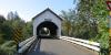
Wimer Covered Bridge
Northeast
Hartman Bridge, middle fork of the Rogue River
Northeast
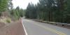
1863 Military Road 1: Highway 140 and Obenchain Road
Northeast
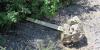
1863 Military Road 2: Fourbit Ford Campground
Northeast
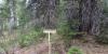
1863 Military Road 3: on 700 Road near Twin Ponds Road
Pagination
First page
« First
Previous page
‹‹
Page
1
Page
2
Page
3
Page
4
Current page
5